California Dreamin'
Points N/A
Solves N/A
Scenario
The Professor has uncovered a critical piece of evidence: a dashcam photo retrieved from a hostile subject’s car, suspected of planning an infiltration at a nearby military installation. Your task is to utilize OSINT skills to stop this threat before it’s too late.
Analyze the dashcam image to determine the exact coordinates where it was taken. Identify the nearest military installation to this location . Find the distance by road (in miles) from the exact coordinates of the dashcam image to the military installation. Round off the mile count to the nearest whole number.
Flag format: QUESTCON{
- } The name should be one word and lowercase
Solution
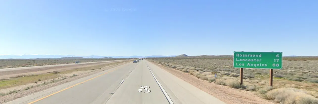
The image is named California_dreamin. The image shows a road sign with the text:
Rosamond 6 miles
Lancaster 17 miles
Los Angeles 88 miles
When we search the text Rosamond 6 miles on Google Maps, we find the location 34.8642, -118.1635. The location is in Rosamond, California, USA. The nearest military installation to this location is Edwards Air Force Base.
The distance by road (in miles) from the exact coordinates of the dashcam image to the military installation is 23 miles.
Flag
QUESTCON{edwards-23}
QUESTCON{edwards-23}